This was written by Sally, my 8 year old daughter, for her third grade writing class. I have added some pictures.
When I awoke at 7:00 it was a bitter cold morning. I walked to the picnic table with sleep in my eyes. The sun warmed me enough. My hot chocolate was as warm as a fireplace. I was on day five on a canoe trip with my Mom, my Dad and brother Brad who is ten years old. The early morning bird songs and silence brought small but happy smile to my face. The water was glistening and the sound of our paddles was soothing. Then the wind picked up and my Dad said “sweep on the left draw on the right”.
 We got to our first portage and ate lunch. After the portage on Umbazooksus Lake that’s when in all happened.
When I first stepped on that tail I know it was not going to be good. I was going to portage the Mud Pond Carry. The first time I stepped in mud it was cold, wet and thigh deep. Then I heard a crinkle and my shoe fell off. I didn’t think I would
 get it back on my foot. Splitter splatter help! False alarm just a frog no a toad. Maybe if I sing I’ll have more fun than being alone 100 bottles of milk on the wall 100 bottles of milk so on. Maybe that won’t work. Yes, I got another frog for my frog count. I wonder how long…
“Oh no what have I gotten myself into now.” It was raining cats and dogs. Not another mud puddle! How about I go around it like my brother? But it’s to big I thought. I didn’t like this I just wanted to go home. I got really grumpy and bored. “Mom do you have a snack?” I asked. The mud was so very cold even my thighs were buried in it. This was hard for an eight year old. “Is that what I think it is?” I wondered. Land. One giant step for me one small step for earth!
Hiking all that was hard but I survived my big journey. I still had one day left and I was kind of glad about it. After all I will admit I did have a good time. My moments alone were full of silence and thoughts, not the regular kind of silence, the kind that helps you think good thoughts. But I did have a good time. By the time I was done I felt pretty good about myself, another small but happy smile.
Sally Gill
When I awoke at 7:00 it was a bitter cold morning. I walked to the picnic table with sleep in my eyes. The sun warmed me enough. My hot chocolate was as warm as a fireplace. I was on day
 five on a canoe trip with my Mom, my Dad and brother Brad who is ten years old. The early morning bird songs and silence brought small but happy smile to my face. The water was glistening and the sound of our paddles was soothing. Then the wind picked up and my Dad said “sweep on the left draw on the right”.
 We got to our first portage and ate lunch. After the portage on Umbazooksus Lake that’s when in all happened.
When I first stepped on that tail I know it was not going to be good. I was going to portage the
Mud Pond Carry. The first time I stepped in mud it was cold, wet and thigh deep. Then I heard a crinkle and my shoe fell off. I didn’t think I would get it back on my foot. Splitter splatter help! False alarm just a frog no a toad. Maybe if I sing I’ll have more fun than being alone 100 bottles of milk on the wall 100 bottles of milk so on. Maybe that won’t work. Yes, I got another frog for my frog count. I wonder how long…
“Oh no what have I gotten myself into now.” It was raining cats and dogs. Not another mud puddle! How about I go around it like my brother? But it’s to big I thought. I didn’t like this I just wanted to go home. I got really grumpy and bored. “Mom do you have a snack?” I asked.
The mud was so very cold even my thighs were buried in it. This was hard for an eight year old. “Is that what I think it is?” I wondered. Land. One giant step for me one small step for earth!Hiking all that was hard but I survived my big journey. I still had one day left and I was kind of glad about it. After all I will admit I did have a good time. My moments alone were full of silence and thoughts, not the regular kind of silence, the kind that helps you think good thoughts. But I did have a good time. By the time I was done I felt pretty good about myself, another small but happy smile.
Sally Gill


 From Halfway Brook to the take-out the river begins to meander a bit so the wind can come at you from any direction. The scenery gets better especially at this time of year as you get views of the foliage on the surrounding hills.
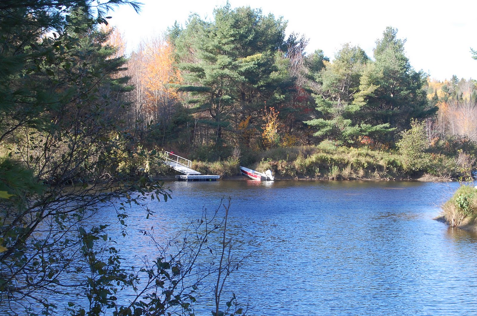
  Five or six miles from the put-in you come to the NFCT carry on river left, it’s reasonably obvious and well marked to the left of the island in mid river. On river right, hidden just around the bend where the right hand channel goes around the island, is the dock and take-out for the Maine Huts and Trails trail. They told me there would be a canoe rack here but they haven’t built it yet.
 The bridge is located just down stream of the old dam shown on the NFCT map. The trail follows the left shore to an outlook with beautiful views of the falls.


 A ¾ mile paddle leads to a nice campsite but Brad insisted we do another ¾ miles to cross over to Gravel Beach in case the wind picked up over night.
 This turned out to be a wise decision on his part and I’m glad he convinced us to do it. It would have been easy to stop early and we would have paid for it the following morning. Gravel Beach was very nice and we set up a clothes line, swam to get clean, admired the brand new outhouse and generally relaxed in the sunlight with dry clothes on.
 Patty and Brad practiced surfing in the waves. Sally and I watched the water crash onto the rocky islands and we enjoyed easy paddling for a couple of hours.
 We stopped at an island to go to the bathroom and found a broken loon egg and carcass of a loon chick.
 We watched the whitecaps out in the middle of the lake and observed a few powerboats trying to make headway into the wind. All too soon we arrived at Chamberlain Bridge got the car packed and headed south.


 Due to the low water levels we were forced to disembark well below the Longley Stream Bridge and then portage east on the road until we could turn north on an obvious side road and re-enter the water on Umbazooksus Lake. We had lunch at the start of the portage. The South end of Umbazooksus Lake is shallow and filled with long abandoned pulp logs.
  After a short paddle through the reeds we reached the west end of the fabled Mud Pond Carry. Both Brad and I were excited to see what this was all about, Patty and Sally, not so much. It began to rain, how appropriate. Time to make some decisions, we reasoned that we could camp here if needed and would look for better options as we started the carry. On our first trip we would bring the canoes and everything paddling related and leave the sleeping gear, food and cooking gear for later trips reasoning that we could return and camp for the night if needed. So, up with the big green umbrellas and off we went.
  The first section up to the road is rocky and dry(ish), about 250 yards in there’s a good campsite on either side of the trail by some old 55 gallon drums. Once you get to the road the water and mud begin. From here to the height of land there are sections of water and mud, some worse than others. In some places you can walk on the side of the trail and stay out of the worst bits but in other places you have no choice but to walk knee deep in the mire and muck.
  Once you near the height of land the trail dries out to a beautiful gravel path through a lovely mature forest, enjoy this section. This is the half way mark so when you start down and the water flows east toward the Allagash you will know you’re more that half way done.
 When you reach a clearing on your left you have about half a mile to go, the worst water is just before the end.

 The paddling was very agreeable and the shore was craggy and interesting as we headed north. We were sheltered from a Northeast wind by Norcross Mountain. Along the way we saw two very interesting things. The first was a brand new beaver lodge on the rock shore of the lake. I cannot see how this beaver is going to survive the winter especially if the water level fluctuates and the ice moves around at all. My guess is that it’s a yearling animal that is in search of a place to settle down. We did get to see the beaver do the tail slap thing. We moved on to leave him in peace in his new house.
 The second event was much more interesting. There are lots of Spotted Sandpipers on the shore and we observed them regularly. At one point a small hawk, probably a Coopers, attacked one of the flying sand pipers, we had great seats for the show. The sandpiper dove into the water and totally submerged for a moment, he then floated with just his head out of the water. After a few seconds he took off and the whole process was repeated again. After the second failed attempt the hawk headed off towards Kineo and the sandpiper returned to hunting along the shore. It’s not very often you get the chance to see a real life hunt in the wild and we discussed and theorized about it for quite awhile.
 This is a very easy portage with wheels as it's a very gradual up hill and then downhill with only a little bit of roughness at the end. We almost immediately passed a couple of large bear scats in the road, its berry season the ursus kingdom.
  We had hoped to stop at the general store along the carry but unfortunatly was closed. Brad did a great job pulling a boat by himself and occasionally Sally rode along in top of the gear.
  The put in at Pittston Farm was spacious and we had lunch while we reorganized the boats for the afternoon. We met a nice family doing the trip up to Lobster Lake and we swapped stories about camping with kids. Unfortunately the wind had picked up and we spent the first hour or so paddling into a head wind, I’ve paddled in worse and with the help of the current we made good progress.
  At the turn off to Lobster Lake the river veers north and the current picks up. We floated and fished for the final two miles to Thoreau’s Islands which we found empty. I did some fishing above the bridge at Hanibal’s Crossing and caught 5 fish in six casts much to the dismay of Brad. After grudgingly helping us get the packs up to the site the kids were free to do whatever they wanted while Patty and I set up the tent, tarp and got going on dinner.
 We had tuna helper for dinner along with some vegetables. I burned the milk and Patty took over the cooking while I pumped a gallon or so of drinking water. The island seems to have a large and healthy Red Squirrel population and I amused myself watching them race around the campsite. We had plenty of wood for a fire and got to bed early for some reading and story telling.

 The day alternated calm sections of flowing water with great, easy white water sections. Brad and I saw an animal swimming across the river and tried to figure out what it was from a distance, it was small. A mink, an otter, muskrat, small beaver? Nope, it was a red squirrel! We laughed about this and tried to figure what would prompt it to attempt such a dangerous mission, after all we had seen plenty of bald eagles and hawks that would love a nice easy dinner. A little later on we saw a second one and this time I got pictures.
 We checked out many campsites all of which were vacant. The sky was blue, there was no wind, the current was strong, and overall it was an incredible section of paddling. We stopped for a nice lunch at some flat rock in a bend in the river and then again shortly later to use the outhouse at one of the many great campsites.
  Soon the river entered Chesuncook Lake and we were paddling current-less flat water again. There was only a minor headwind with beautiful scenery and pleasant paddling. The water seemed very low and we observed lots of signs of the old logging operations that used to take place here, I think we even paddled a set of rapids that only shows up in these rare low water conditions.
 We arrived at Boom House Campsite at about 3:00pm; the site is named after the house that protected the winch that controlled the log boom at this location. I told the kids it was named after the sound that the house made when it blew up but they didn’t believe me.
 Two of the owner’s kids were out in the yard spraying each other with fire hoses when they were supposed to be watering the garden. Mrs. Surprenant was busy canning vegetables but she was happy to sell us some home made home made birch beer. We sat on the front porch and looked at Katadin in the distance and hummingbirds in the foreground as we drank our sodas.
  We realized how disgusting we were and headed back to clean off in the river. The trail back has several relics from the logging years.

 At 3:00am I awoke to prove that I had re-hydrated sufficiently and noticed some cirrus clouds moving in, not a good omen.
